
HISTORICAL ANALYSIS
The White Bay Power Station is located in the suburb of Rozelle, 3km west of the Sydney CBD and is part of Urban Growth’s Bays Precinct Transformation Program. The Bays Precinct has a rich indigenous, multicultural and industrial history of transformative functions for Sydney and Australia. It was a place of trade between Aboriginal clans and became an essential part of maritime commerce in the new Colony. The following site analysis explores the history of the White Bay Power Station site from its geological formation until its use into the present day. The ‘Power Plants’ phytoremediation project is ideally suited as an urban laboratory and demonstration project. It is a temporal project implemented during the pre-development phase, which aims to remediate soils in the WBPS post industrial site. The ‘Power Plants’ project also has a number of educational and engagement activities which are expressed through the performance video.
LANDFORM AND SETTLEMENT
Pre - 1788
The Sydney Basin was formed when the earth's crust expanded, subsided and filled with sediment between the late Carboniferous and Triassic periods. Coal deposits accumulated and the upper parts of the basin were covered in quartz sandstone by extremely large braided rivers that flowed in from the south and the northwest to deposit the Hawkesbury Sandstone.
The topography of the Drummoyne and Balmain peninsulas displayed naturally occuring dips or ‘bows’ along their ridges. This informed the way the landscape was used and travelled from long before European settlement, including how the area was occupied by the native Aboriginal tribes of the Wanngal.

UTS (2018)

UTS (2018)
RECLAMAMTION
1840 - connecting glebe island
The rocky outcrop known as Glebe Island was originally only accessible from the Balmain shoreline at low tide, until a causeway was laid in the 1840s.
1855 - bRIDGE CONSTRUCTION
In 1855 White Bay was still a mud flat. In 1862, a low-level timber framed bridge was built that connected the island to Pyrmont, and thus to the city. Around 1890 a dyke was built from Balmain across the mud flat to Glebe island which reclaimed the land at the head of the bay for a public reserve.
In the middle years of the 19th Century, there was considerable pressure to subdivide Balmain for housing to accommodate the workers in such industries as the abattoirs on Glebe Island, W.Bell Allen’s boiling down works, timber milling in Rozelle Bay and Cowan and Isreal’s Soap and Candle factory on the Annandale foreshores.

The rocky outcrop known as Glebe Island was originally only accessible from the Balmain shoreline at low tide, until a causeway was laid in the 1840s.
UTS (2018)

By 1855 subdivision was well established around the head of White Bay which was still a mud flat. In 1862, a low-level timber-framed bridge was biult that connected the island to Pyrmont, and thus to the city.

Around 1890 a dyke was built from Balmain across the mud flat to Glebe Island which reclaimed the land at the head of the bay for a public reserve.
TRANSPORT AND INDUSTRY
1855 - the opening of the sydney goodsline
After the construction of the main rail line from Central Station to the far West, the Sydney Goods Railway Line opened in 1855. Following naturally occurring troughs and ridges, the rail line linked the region’s resources to the Harbour of Sydney.

UTS (2018)

UTS (2018)
FORMATION OF THE INDUSTRIAL BELT
1900'S
Following the construction of the Goods Line Railway, heavy industry claimed the perimeter of the harbour in White Bay, Johnstons Bay, Blackwattle Bay and Darling Harbour. This was also known as the ‘industrial belt’. A strong pride in industrial advancement with heroic buildings and infrastructure was achieved at the expense of the health and ecology of the natural landscape, for example industry heavily contaminated the soil of the site.
With the spread of industry along the shoreline in the middle years of the 19th century there was considerable pressure to subdivide the land for housing to accommodate the workers in such industries as the Abattoirs on Glebe Island, W Bell Allen’s boiling down works, timber milling in Rozelle Bay and Cowan & Isreal’s Soap and Candle factory on the Annandale foreshores.
LOCATING THE SITE
1911
The White Bay Power Station was sited at the head of White Bay to make use of the location’s close proximity to water. The rail line at this site brought coal in, both for use in the power station and for export from the harbour.

UTS 2018

UTS (2018)
POWERPLANT OPERATIONS
The 3.8 ha site contains the former coal fired power station which was first commissioned in 1917 by the Department of Railways. The power station provided additional electrical power for the Sydney tram network and it remained online until its decommissioning in 1983. Along with being an important contributor to Sydney’s industrial capacity the White Bay Power Station was also an important generator of social and economic gain for communities of Rozelle and Balmain by providing stable employment to generations of its residents.
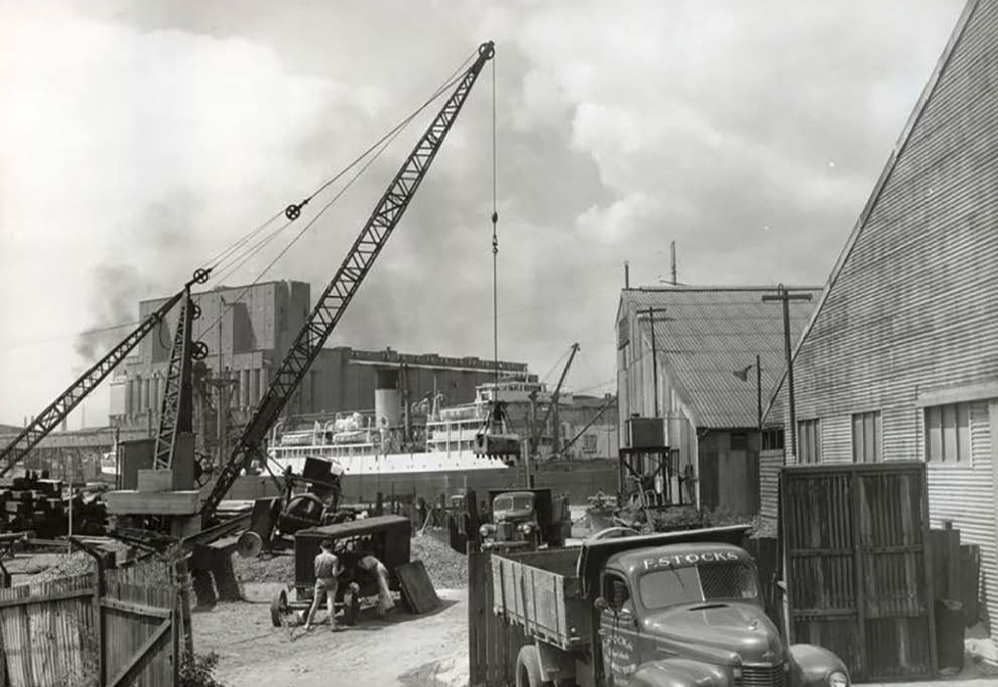
IMPORT & EXPORT OF COAL
1917 ONWARDS
White Bay Powers tation was not only a site of energy production through coal burning. Coal was brought along the Goodsline and across the Pyrmont Bridge to the Power station. The coal was then crushed once, with 50% of the coal being distributed locally for energy production and the remaining 50% being used for international trade.
The coal was then crushed a second time and utilised at smaller powersstations such as Balmain, to produce enough energy for Sydney's growing population.
Work yard, WBPS

Cooling canal leading to WBPS

Coal Shovelling, WBPS

Material Storage, WBPS
THE SITE AS IT IS TODAY
White Bay Power Station was decommissioned in 1983 and has stood abandoned and fenced off ever since. White Bay power Station has recently been used as a film set for productions such as The Matrix reloaded, Mad Max Fury Road and The Great Gatsby. It is often used as a backdrop for fashion shoots as well as romanticised through online photography blogs.
Urban Growth NSW and the Bays Precinct Team is looking beyond these temporary uses for a new or adaptive way to revitalise this iconic part of Sydney’s built industrial past, a way that can maintain the heritage listed Anglo-Dutch style of its buildings. It is anticipated that over a fifteen year time frame a master planning solution will be found and implemented. This began in February 2011 when the Sydney Foreshore Authority opened the site up to the public to expose them to the diverse character of this piece of industrial infrastructure and to encourage people to submit ideas for its future use. The planning and design work has continued through many proposals but with no long-term propositions being adopted to date. Recently, a team of consultants were appointed to design a master plan

Lost Collective image a Control Room at WBPS (Patman, B. 2015).

The Bays Precinct Transformation Plan identifying the opportunities for redevelopment at each of the eight ‘destinations,’ (Urban Growth NSW, 2015).
![transport map[Converted].png](https://images.squarespace-cdn.com/content/v1/5a03daecb7411ccad1e9edb2/1535347351379-3EKFA0P440OQT7ZFF6JF/transport+map%5BConverted%5D.png)
TRANSPORT TODAY
Major transport routes today are a product of the topography, the Harbour and the settlement pattern. The White Bay Power Station is at nexus of these routes. These have resulted in strategic benefits but also natural environmental impacts.
UTS (2018)

Lost Collective image of the pedestrian bridge leading to the administration entrance at WBPS (Patman, B. 2015).
THE BAYS TRANSFORMATION PLAN
The eight destinations, including White Bay Power Station, within the Bays Precinct total 95 hectares of land and 94 hectares of Sydney Harbour. The Bays Precinct today wraps part of the iconic inner Sydney Harbour and is surrounded by well established urban villages.
Its waterways and most of its land is Government owned and predominately used for port, maritime and commercial uses with a significant part of its 5.5 kilometres of foreshore not being publicly accessible. The Bays Precinct contains several significant heritage items like Glebe Island Bridge and the White Bay Power Station, which was built on the shores of White Bay to power Sydney’s tram network.
The White Bay Power Station (WBPS) is one of the key destinations for action by Urban Growth NSW and Landcom and will anchor a broader innovation district that when completed will also incorporate Glebe Island.
“We want White Bay Power Station to be the best example in Sydney of how living, working and learning can be woven together to create a prosperous and thriving economy. This requires us to think about the most appropriate mix of uses, including residential, for the Power Station and surrounding land and how this can benefit nearby areas, We want to activate the Destination outside working hours, position the Power Station at the heart of The Bays Precinct, and draw on international examples that have returned industrial spaces to their cities. A global and regional destination within the Asia-Pacific that co-locates research, business, education, science, academia, technology and start-up incubators to drive global competitiveness and innovation is part of our vision for The Bays Precinct,” (Urban Growth NSW, 2015).
The Transformation Plan is the strategy document for delivery of the Bays Precinct and outlines a number of key principles and objectives, including:
• Building on the unique history of the Bays Precinct (Principle 1)
• Unlock public access to the Harbour’s edge and waterways along the entire coastline (Principle 5)
• Prioritise planning for public spaces, White Bay Power Station and Sydney Fish Market (Principle 8)
• Build the capacity for The Bays Precinct to be a place that contributes to healthy, prosperous and resilient lifestyles (Principle 11)
• Introduce environmental and ecological systems to improve water quality, address ongoing sources of water pollution and encourage public recreation (Principle 15)

TOPOGRAPHY TODAY
Steep topography near the harbour limited the usability of shorelines. On the South side of the harbour between Balmain and Darling Harbour, much land was reclaimed from the sea to provide platforms that take advantage of the deep water harbour. The White Bay Power Station and its flat surrounding land is a part of the story of the challenge of Sydney’s topography.
UTS (2018)
soil conditions
Due to the heavy industrial history of this site the condition of the soil has greatly deteriorated and is in need of remediation, there are a number of contaminants on site. This places it as an ideal location for the Power Plants project to test a range of annual species and their ability to absorb these toxins. The soil conditions were matched to the species selected and are further explored in the GARDEN DESIGN.